

You can find on this page the Iceland road map to print and to download in PDF. The Iceland driving map presents the detailed road network, main highways and free motorways of Iceland in Northern Europe.

The Iceland road map shows all roads network and main roads of Iceland. This road map of Iceland will allow you to preparing your routes and find your routes through the roads of Iceland in Northern Europe. The Iceland roads map is downloadable in PDF, printable and free.
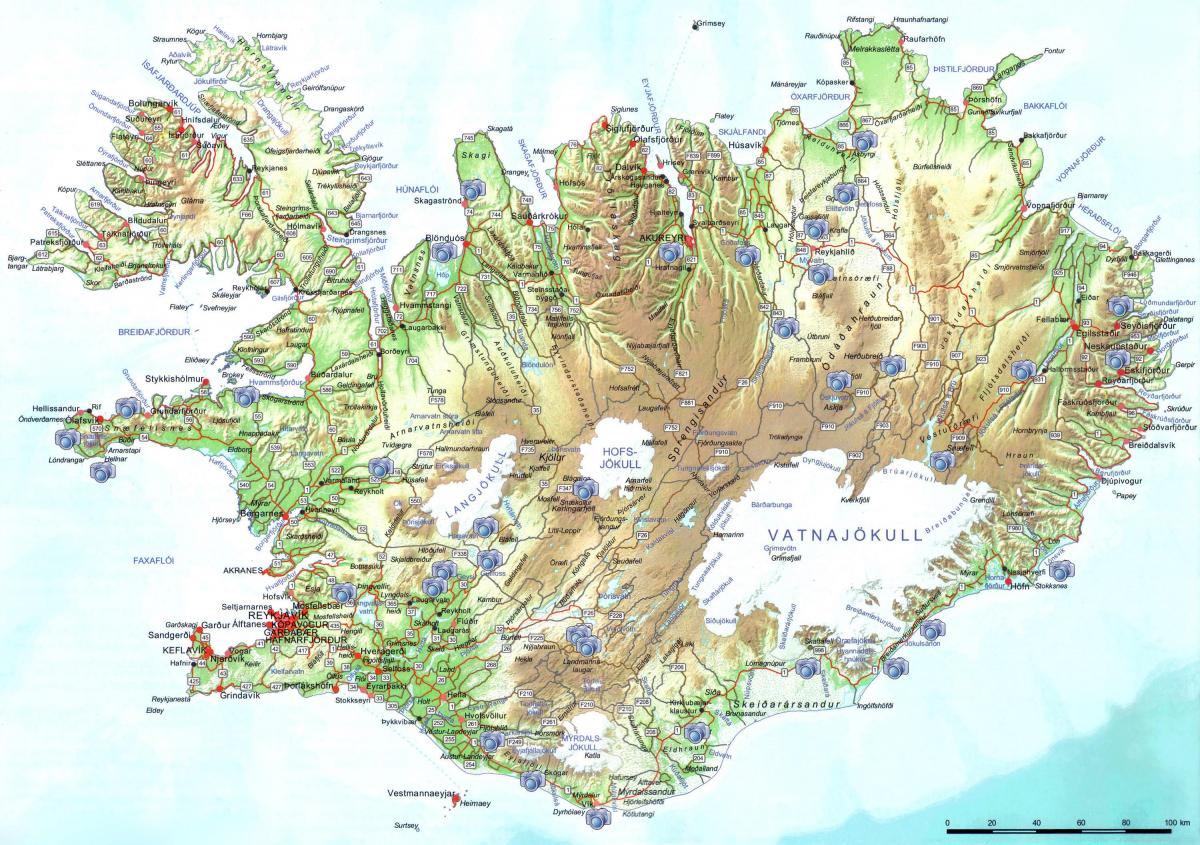
5,040 kilometres (3,130 mi) of Iceland of publicly administrated roads are paved as you can see in Iceland road map. Organized road building began about 1900 and has greatly expanded since 1980. Vegagerðin (Icelandic Roads Administration) is the legal owner and constructor of the roads, and oversees and maintains them as well. Speed limits are not posted frequently in Iceland, but these are the general speeds. Drivers are asked to drive at a speed appropriate for the road and weather conditions. 50kph in populated areas, 80kph on gravel roads, 90kph on paved roads (This is the top speed in the country). Primary roads connect cities, big urban areas, airports and harbours. They are usually tarmacked, but not every time. The most famous primary road is the Ring Road, which goes around the whole island and through the main cities of Reykjavik and Keflavik.
Roads in Iceland have different types of surfaces as its shown in Iceland roads map: Tarmac/Paved: Most major highways are paved. Gravel: A large number of other roads are gravel. Roads in Iceland are generally in great condition, but it is important to stay alert for potholes and slippery patches. Additionally, the area where the road switches from tarmac to gravel is very dangerous and causes many accidents, so be sure to drive slowly in these places. F roads/Mountain Tracks: These are the mountainous roads in the center of the country. Conditions are difficult, even when the weather is pleasant. They are often closed until June or later, and 4 Wheel Drive (4WD) is necessary for traversing them.
Route 1 or the Ring Road (Icelandic: Þjóðvegur 1 or Hringvegur) is a main road in Iceland that runs around the island and connects most populous parts of the country. The total length of the road is 1,339 kilometres (832 mi) as its mentioned in Iceland roads map. For almost all its length, the road is two lanes wide with one lane in each direction. Where it passes through larger towns and cities it may be expanded to more lanes, as well as in the Hvalfjörður Tunnel. Most smaller bridges are single lane and made of wood and/or steel. The road is paved with asphalt for most of its length, but there are still stretches in the eastern part of the country with an unpaved gravel surface. The Iceland Road Administration, Vegagerðin oversees the maintenance and creation of national to small access roads in the country. Traffic on the road varies depending on location; in and near Reykjavík it is around 5,000–10,000 vehicles per day, but the stretches farthest away from larger towns see fewer than 100 vehicles per day on average.

The Iceland highway map shows toll and free motorways of Iceland. This highways map of Iceland will allow you to prepare your routes on motorways of Iceland in Northern Europe. The Iceland highway map is downloadable in PDF, printable and free.
The circular highway around the main part of the country that loosely follows the coast is designated as road number 1 as you can see in Iceland highway map. All vehicular traffic in Iceland is on the right hand side of the road and international traffic signs are used but there are always some special things to keep in mind when on a self drive trip in a new country. The Ring Road is 1,328 kilometres long (825 miles). That is the equivalent of driving part of the United States east coast, from Boston, Massachusetts, to Charlotte, North Carolina. Or driving the full length of the UK from John o’Groats in Scotland to Penzance in south-west England. Basically, the Ring Road covers most of the country, as shown in blue on the map above. It bypasses part of North Iceland (in red), the Westfjords (dark blue) and the Snæfellsnes peninsula (purple). These can always be added to a summer itinerary for a deeper exploration of Iceland.
Highway no. 1, commonly known as the Ring Road or Route 1, is the most traveled road around Iceland. All 1322 kilometers of the Ring Road are paved and open throughout the year, although bad weather conditions during winter can cause temporary and local closures. F-Roads or mountain roads (the F standing for “Fjall” which translates to “mountain”) as its shown in Iceland highway map lead you to the heartland of Iceland and are only open for a short time during summer. If you are planning on driving into the highlands, be sure that you have a four-wheel-drive jeep with good ground clearance to tackle the rough terrain and cross rivers.
Most visitors choose to drive Iceland Ring Road in summer. At this time of year, the midnight sun gives you plenty of extra daylight for driving and sightseeing. But winter road trips are also possible, and growing in popularity. Although the conditions will be less ideal than in summer, there is plenty to be enjoyed during the winter months. The natural highlights will all be there, and as stunning as ever with frost and snow (see Iceland highway map). You may even spot the northern lights in the dark skies.